Posted
Top 5 Hikes in The Crowsnest Pass
Posted:
Nestled in the southern Canadian Rockies, the Crowsnest Pass – or fondly referred to as “The Pass,” boasts spectacular scenery, a rich coal mining history, friendly communities, and great hiking. Whether you’re just passing through and want a short hike to break up the drive, or have a weekend to bag some peaks, there is a wide range of trails in The Pass that will take your breath away.
While lack of signage has been an issue in the past, local outdoor organizations are changing that by adding trail markers and signs on more popular trails. Further, the Crowsnest Pass hiking brochure has been replaced with the Trailforks App, making it easier than ever to get detailed information on hiking and mountain biking trails in the region.
With so many hikes to choose from, I called upon local residents, Pam Drover and Heather Davis, to help select the top 5 hikes in the Crowsnest Pass

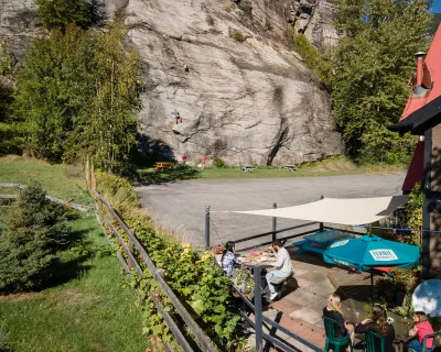
Photo:
Pam Drover
View from Turtle Mountain
1) Turtle Mountain - North Peak
6.2 km return, 900 m elevation gain
“Turtle Mountain is an all-time favorite… that most people want to do,” Heather Davis says. Known to First Nations as “the mountain that moves,” Turtle looms over The Pass and is responsible for Canada’s deadliest rockslide. Over 80 million tons of rock - the turtle’s shell - came crashing down on the town of Frank in 1903.
While Turtle Mountain continues to move, ever so slightly, its seismic activity is monitored to predict future landslides. If you dare to hike to this mountain top, you will get a bird’s eye view of Frank Slide and the surrounding peaks.
Directions: The parking for Turtle Mountain is located at the end of a gravel road near 134 Street and 15 Avenue in Blairmore (GPS coordinates: 49.602986 -114.427071). To get there, turn left onto 129 Street from Highway 3. Take a left at 19th Avenue, then right on 132nd Street; 132nd will turn into 15 Ave. At the T-intersection, turn right. 1 block later, take a right onto the dirt road across from the cul-de-sac. Follow it for about half a kilometre to the parking area at the top of a rise.
Yellow markers painted at the base of the cliffs just past the parking area indicate the trailhead. Follow the markers and well-trodden trail to the first summit (North Summit). Allow an additional 30-60 minutes to reach the second summit (South Summit). There is considerable exposure and loose rock on this trail so wear good hiking boots and stay back from the edge where boulders perch precariously. Return the way you came.

Photo:
Karen Ung
On April 29, 1903 at 4:10 in the morning, 82 million tonnes of rock fell from the summit of Turtle Mountain. In 90 seconds, the rockslide became the deadliest in Canadian history. Today, in the remnants of the slide sits an Frank Slide Interpretive Centre detailing the why and how of it all and a self guided trail where the devastation is palpable. http://ow.ly/bOde30e7jzy #BucketListAB
2. Frank Slide Interpretive Trail & Leitch Collieries
1.5 km and 800 m respectively
A 1.5 km interpretive gravel trail meanders through boulders left in the wake of Frank Slide. To learn about life before, during, and after the slide, visit the Frank Slide Interpretive Centre ($) adjacent to the trailhead. The tales of heroism and survival, revealed through film and exhibits are incredible.
Nearby Leitch Collieries Provincial Historic Site, east of Bellevue, is another must-see. Explore the ruins of this high-tech (for its time) coal mining operation on a 0.8 km wheelchair accessible trail. Admission by donation.
Directions: Frank Slide Interpretive Trail and Leitch Collieries are located on the Crowsnest Highway (Hwy 3) and very well marked.

Photo:
Karen Ung
Learn about local coal mining history at Leitch Collieries Provincial Historic Site.
Leitch Collieries was one of the most impressive and sophisticated coal mines in the Crowsnest Pass, take a break from driving to unwrap some history and find out what went wrong at this "bad luck mine". http://ow.ly/CBwI30e7lHf #BucketListAB
3. Window Mountain Lake
4.4 km round trip, 218 m elevation gain
Beautiful Window Mountain Lake is a local’s favourite. Whether you go for the fishing or the views, you will fall in love with this pretty, alpine lake. Ironically, you can’t see the window in Allison Peak from the lake, but there’s a small island near shore that is fun to explore.
Directions: Access to this spot is tricky and there is no signage on the logging road, so follow these directions carefully: 5 kilometres west of Coleman, turn right onto Alison Creek/Atlas Road. Re-set your odometer to zero. Keep right at the turnoff for Chinook Lake (3 km). Look for a pullout on the right 16.5 kilometres from the highway (just past kilometre marker 14 if you forgot to re-set your odometer). Across the road, you will see a narrow, steep road. Hike 1.4 km up this road to the trailhead. If you have a high clearance vehicle, you can try driving the first kilometre, but the road is really rough. Follow the spray painted WML markers 800 metres to the lake.
Going Further: Hike around the lake (2 km loop) or scramble to the top of Mount Ward for spectacular views (add 1.6 km one way and 470 m elevation gain).

Photo:
Stacy Head
Star Creek Falls at sunset
4. Star Creek Falls Loop
1.6 km loop, 114 m elevation gain
Star Creek Falls is a hidden gem in West Coleman. The cool features of this short, but scenic hike include two bridges, two viewpoints of the falls, and a 75-metre deep canyon.
Directions: From Frank Slide, head west on Hwy 3. In Coleman, turn left onto 19 Ave, turn right on 70 Street, right on 17 Ave (turns into 67 St after the railway tracks), turn right on 16 Ave, turn left on 54 Street to reach Star Creek Staging Area. The trailhead is at the end of the road at the top of the hill. The last 200 m of the road is very rough; vehicles with low clearance should be parked at the bottom of the hill.

Photo:
Anna Kroupina
Sweeping views of the Seven Sisters (right of centre) from Crowsnest Mountain
5. Crowsnest Mountain
10.8 km return, 1100 m elevation gain
The pre-eminent peak in the area is Crowsnest Mountain, known locally as, “The Crow”. Visible throughout the Crowsnest Pass, this distinctive mountain offers fun, but challenging scrambling, and epic views of the Seven Sisters. Route finding and intermediate scrambling skills are required. Beware of rock fall, loose rock, and exposure. A detailed route description is available on Trailforks.
Directions: From Highway 3, 5 km west of Coleman, head north on Allison Creek/Atlas Road for 9.7 km (watch your odometer). Turn right and go straight for 100 m to the trailhead.
For more information on things to do in the Crowsnest Pass, visit gocrowsnest.ca.